climate and ocean modeling
WORKSHOP 1
Climate and Ocean Ecosystem Modeling
Predicting the State of Oceans and Fisheries in the North Pacific and Bering Sea
The basic water cycle, which consists of evaporation, condensation, and precipitation, reminds us that everything starts in the ocean. Earth’s temperatures have been rising due to global warming, and about 90% of this excess heat has been absorbed by our oceans. If we want to better understand climate change impacts in the Pacific basin and where major problems for atmospheric conditions are being generated, we must take a closer look at our changing oceans. Currently, there are no basin-wide scaled models, as scientists have mostly focused on coastal zones.
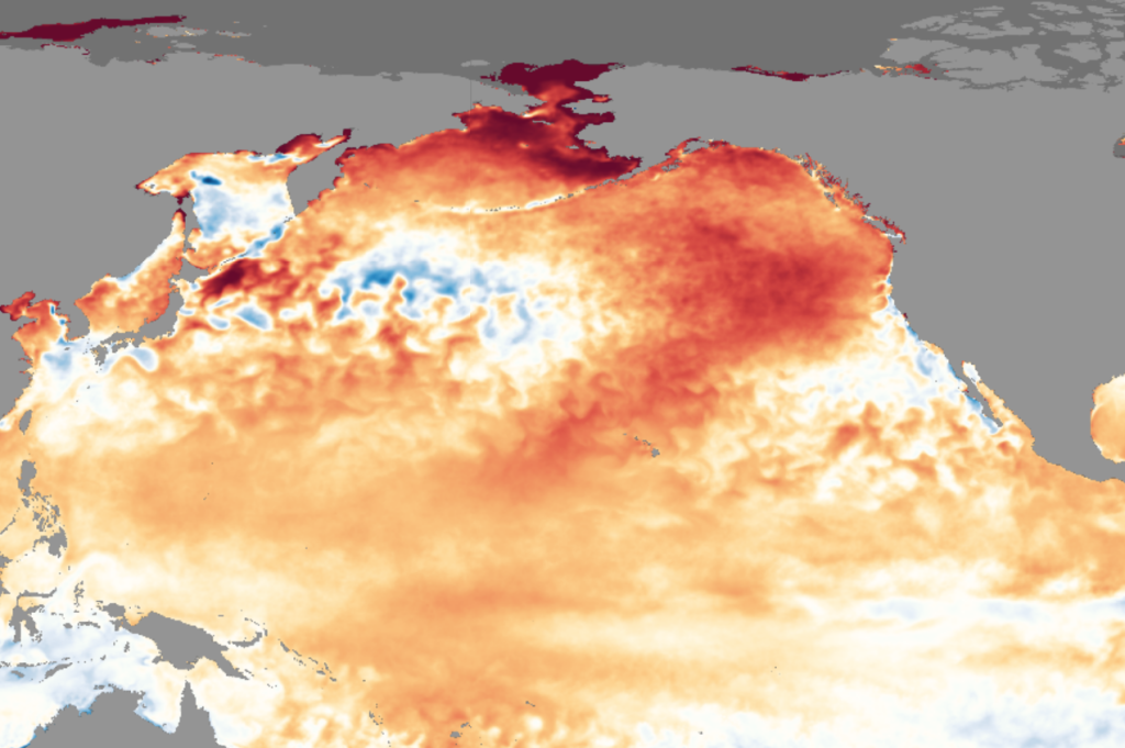
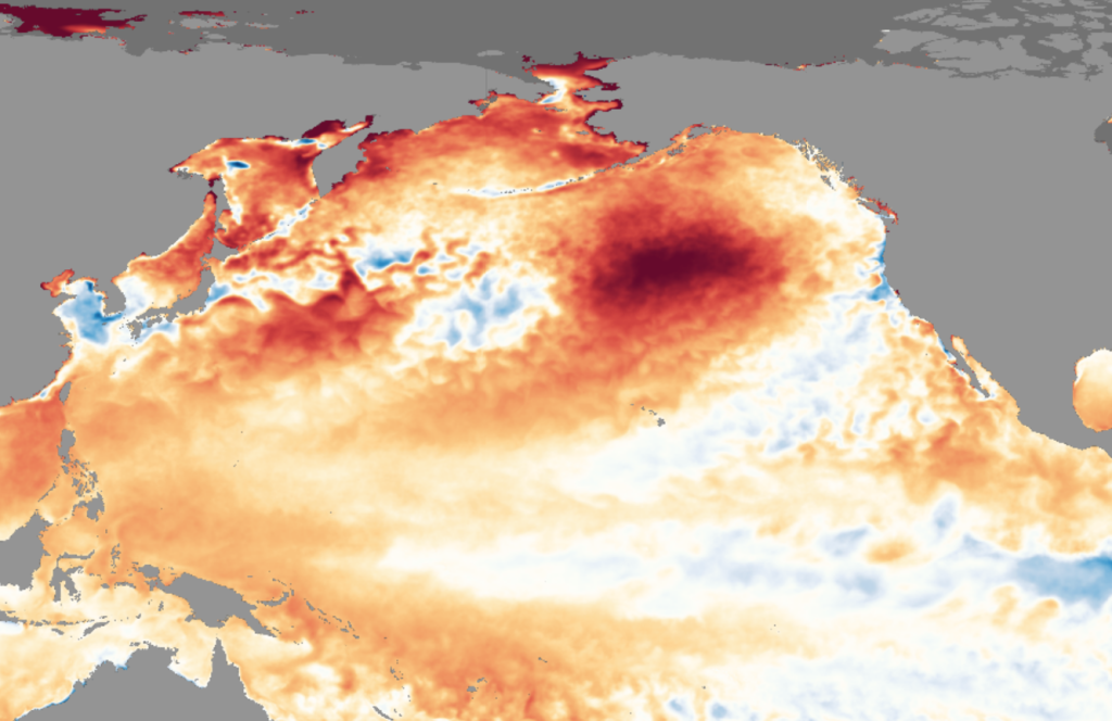
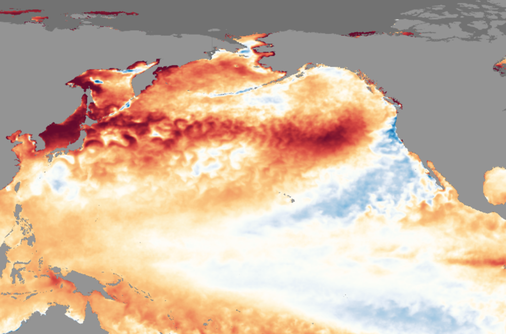
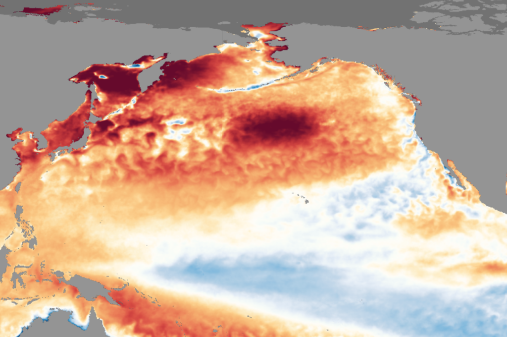
The daily Sea Surface Temperature Anomaly dataset presented here shows areas that are cooler (blue) or warmer (red) than the historical baseline temperatures. This modeling is derived from NOAA’s View Global Data Explorer.
The Intergovernmental Panel on Climate Change (IPCC) has concluded that rapidly accelerating climate change caused by human influence has warmed our atmosphere, oceans, and land, and the scale of these recent changes across the climate system is unprecedented. In their reports, the IPCC note that ocean surface temperature will continue to increase until at least mid-century under all emission scenarios that they considered. The IPCC report on Impacts, Adaptation and Vulnerability noted that climate change has caused substantial damage, and increasingly irreversible losses in open ocean marine ecosystems, that ocean warming and ocean acidification have adversely affected food production, and that future vulnerability of ecosystems to climate change will be strongly influenced by their use (or misuse) and management of the ocean.
Climate models - what do we know?
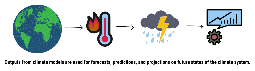
Climate models are tools that help us better understand and predict changes to our climate. Global climate models use mathematical equations to make calculations around the processes driving Earth’s climate – the major system components covered by these equations are those of the atmosphere, land surface, the ocean, and sea ice. Outputs from these models are then used for forecasts, predictions, and projections on future states of the climate system. They help drive climate science and inform scientists on how human impact is affecting the climate. They also inform policy and management decisions.
Currently, global climate models and Earth system models show that significant changes in the North Pacific are underway and show no signs of stopping, as the magnitude of future change continues to increase with increasing CO2 emissions. These models have formed the basis of many IPCC Reports. However, sometimes individual global climate models can be unreliable. Using multi-model ensembles and downscaling to regional and subregional scales are ways to deal with their limitations and resolve critical features of the ocean that are relevant to policy makers and managers.
Extreme climate states such as ocean acidification, marine heat waves, and low oxygen concentrations are expected to increase and will become critical in understanding and predicting biological outcomes. There are ways to use models and observational data to make ecological forecasts and projections that will help us better adapt to a changing climate. FishMIP is an international collaborative project that uses ensembles of global climate models to drive ecosystem models “to help better understand and project the long-term impacts of climate change on fisheries and marine ecosystems, and to use our findings to help inform policy.”
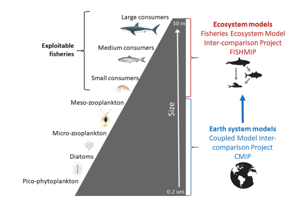
Figure 1: FishMIP diagram (source: https://www.isimip.org/about/marine-ecosystems-fisheries/)
The results from downscaling of global climate models to regional climate models can be used to drive higher resolution ecosystem and fisheries models and the next generation of ocean projections for living marine resource management in a changing climate, in comparison to increasingly unreliable assessments based on historical data. Different regions (for example, the Western and Eastern North Pacific) may require significantly different approaches due to the differences in their physical oceanographic? processes. Downscaled models are being used to both drive and connect to a diverse range of ecosystem models, which include species distribution, food-web, life history, and socio-economic models, amongst others. Enhanced observational data can be used to improve and validate the model projections.
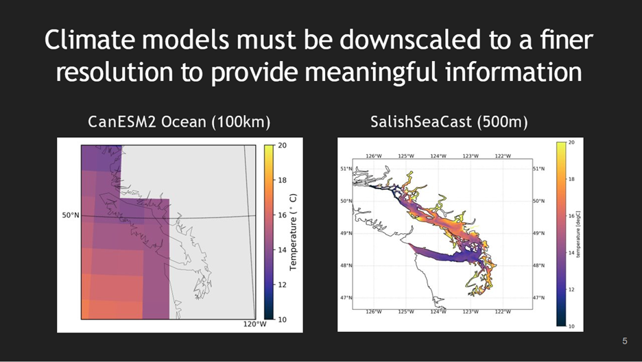
Figure 2: Spatial resolution in global climate models (~100 km resolution) compared to sub-regional scale models ~500 m resolution) Figure from Amber Holdsworth
Climate models - gaps and what we don't know
Global and even downscaled regional models cover areas that span multiple jurisdictions, and access to the computing power needed to run these models can be limiting. Scientists also lack some important knowledge on the mechanisms by which changes in the physical environment affect the distribution and/or abundance of species. Communication amongst a diverse range of practitioners, including scientists, policy makers, resource consumers, resource managers, Indigenous and other ocean-dependent communities, needs to improve dramatically. This lack of communication occurs between nations, but also across and even within various organizations. In many organizations and nations, climate modeling activities are dispersed across organizational units and focused on what are often narrow objectives – there is a need to move to a smaller number of aggregated efforts to satisfy multiple requirements. There is also a crucial need for international collaboration for basin-scale modeling and regional intercomparisons. There is important work ahead to plan optimal deployment of observations to validate these models.
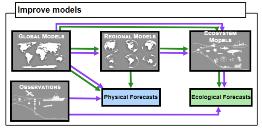
Figure 3: Pathways for using for using model and observational data to make ecological forecasts/projections. Figure from Mike Jacox
Climate models - what do we need to address gaps?
Currently, output from earth system and global climate models has not been sufficiently utilized. There remains a lot to be learned from existing results, which can be further analyzed through inexpensive research that can be implemented quickly and with modest resources. To downscale global climate models, support is needed to coordinate these efforts, and explore and utilize new and lower-cost opportunities for cloud-based computing. Looking at ensembles of models, as opposed to single models, could be very useful, and it adds opportunity to look at tools for collaborative virtual data/knowledge centers. This can also improve access to outputs from ocean models and aid in the participation of international collaborative research efforts. This would also encourage bringing together the support, efforts, skills, and interests of both government agencies and university investigators across national boundaries.
Understanding climate change and its impacts on ecosystems is already a difficult and complicated process, which is further complicated by extreme events and weak predictability at time scales most important to humans (seasonal to decadal). Better communication and coordination between ecosystem modellers, oceanographers, and fisheries scientists will help sustain research to understand how changes in physical and biological environments impact current and future climate conditions. Stakeholders and communities understand that using models, coupled with improved monitoring data to better predict how to respond to changes in ocean and marine ecosystems must be a crucial part of the conversation. Stakeholders should be engaged early to prepare them for information that will help comprehend needs for specific management decisions, and can also benefit from citizen science to acquire the data required to constrain climate models.