technology

WORKSHOP 3

technology and tools

For monitoring and data synthesis

In Workshops 1 and 2 we learned that high resolution ocean models developed by down-scaling global climate models can be coupled with ecosystem and fisheries models to understand how the ocean is responding to climate change and to generate timely ecological/fisheries forecasts.  This is an approach to climate adaptation that can be used to build resilience for coastal economies as they deal with climate extremes now and for the foreseeable future.   

We also learned that in order to understand the state of the ocean and to refine the skill of these models over time, intense near-real time monitoring will be needed.  The level of effort required to monitor the entire NPO basin across four seasons is certainly beyond the capacity of existing research fleets and current monitoring approaches.  Francisco Chavez, the Chief Scientist for the Monterey Bay Aquarium Research Institute (MBARI) eloquently notes that we need to “greatly increase our ability to observe and quantify how and why life in the sea is changing”.  He argues that there are no systematic global efforts to observe life in the sea because of a lack of scalable methods.   

Fortunately, we are at a time of rapid technological change when the application of evolving remote- sensing and emerging uncrewed technologies may provide a cost-effective solution.  In Workshop 3 we brought technical subject-matter experts together to advise on the state of development and applicability of these technologies including but not limited to gliders, drones, buoys, satellites, fish tags, eDNA, and data systems. 

eDNA (environmental DNA) onboard the NOAA Bell M. Shimada for the 2022 Pan-Pacific Winter High Seas Expedition

spotlight on emerging technologies

Can emerging technologies provide cost-effective solutions to our need for high resolution monitoring of the ocean? 

The short answer is yes! The new and existing technologies highlighted in this workshop clearly demonstrate that a well-designed implementation of remote sensing, ships, autonomous vehicles, moorings and tagging tools can deliver a cost effective near-real time monitoring framework for the NPO.  

Uncrewed Autonomous Vehicles:

The following figure, provided by Seth Danielson from the University of Fairbanks Alaska, shows the range of autonomous uncrewed vehicle (AUV) sensors available now and in the near future:

Platforms that can carry these sensors are becoming increasingly capable. Uncrewed surface vessels (USVs), are ready to join the Global Ocean Observatory System with at least a dozen USV’s operating commercially in the open oceanUSVs have operated in hurricane strength winds, low wins, all latitudes, in strong currents, in high waves, and in semi-enclosed seas. Saildrones are wind-and-solar powered USVs which are capable of up to 12- month ocean data collection missions, monitoring the planet in real time.

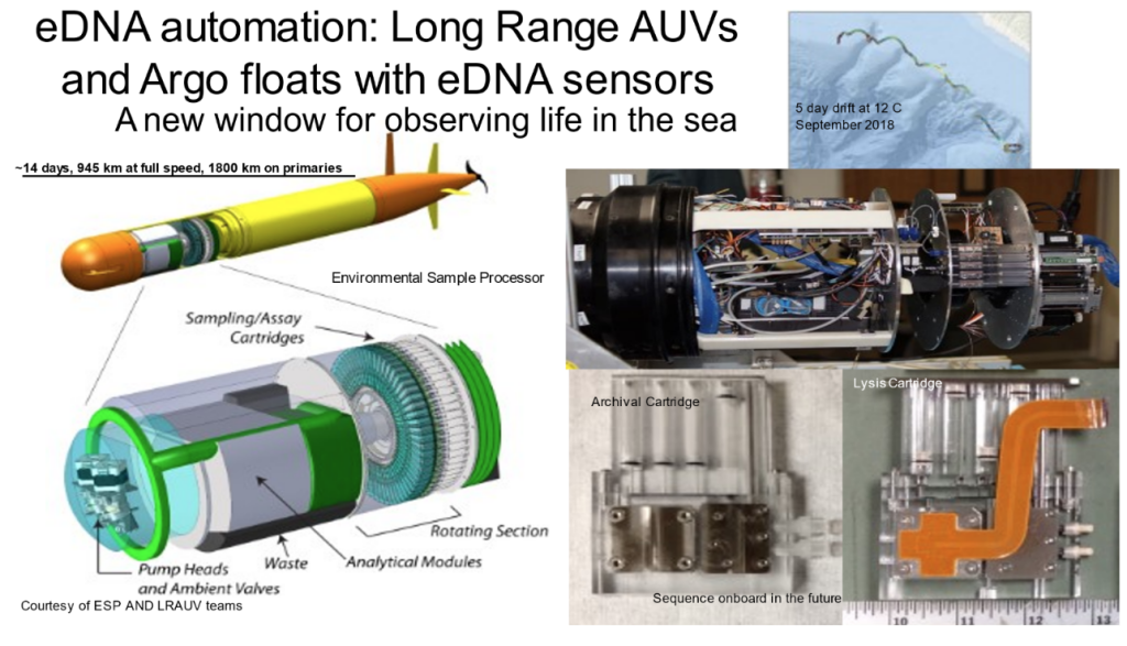
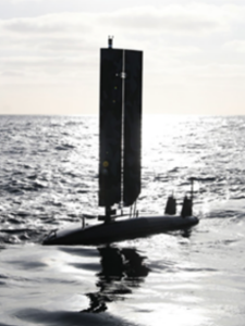
An example of a successful USV is Triton’s Aero, a hybrid ocean glider and sail drone which can operate in surface or underwater dive mode. Sail drones and ocean gliders now have the ability to carry hydroacoustic packages and conduct eDNA sampling, which, coupled together, have the potential to be the backbone for monitoring the biodiversity of open ocean ecosystems. As an example, Charles Hannah, a research scientist with Fisheries and Oceans Canada, suggests that in the open ocean, combining an acoustic profiler on a sail drone with Argo floats (sub-surface profiling floats which observe temperature, salinity, and currents) could help characterize salmon, their prey, and the environment. For coastal zones, more traditional methods of ocean mooring could be combined with novel glider and sail drone technology. Tracking the development and implementation of these technologies is important.  The UNDOS OASIS project (airseaobs.org) is proposing a community of practice under the GOOS for tracking the state of uncrewed ocean surface vehicle technology. (Photo credit: Andy Ziegwied –  Ocean AERO Triton )

Fracisco Chavez

Remote Sensing:

Remote Sensing has been with us for some time.  What can we expect in advances with satellites? 

Remote sensing is an observational technique that allows scientists to use radiation measure properties on the ocean surface with sensors attached to aircrafts like satellites or planes. Remote sensing already has the capacity to measure Sea Surface Temperature (SST) and continues to advance in producing high resolution measurements of essential ocean variables which are increasingly capable of studying the mechanisms affecting fish productivity and distribution. Over the next several years, new satellites will be available and online which will increase resolution dramatically, and new altimetry sensors attached to these satellites will revolutionize hydrology. Remote sensing requires information provided by ground-truthing (direct observation) from in situ samples (measurements directly from the sea). BECI can help play a role in strengthening these needs.  


Maycira Costa

Fish Tagging:

Learning where fish are in the ocean and assessing their condition across their life history will be a key requirement for determining how changes in the ocean will affect them.  What technology will assist in the study of fish migration, distribution and health. 

Tagging fish is a popular approach to determining the distribution and migratory patterns of fish. These approaches range from simple physical tags, which identify information and provide information of movement when the fish is caught, to sophisticated electronic tags, which can archive or transmit information about the fish’s position to satellites or broadcast unique radio signals.  

Acoustic tags are now small enough to be applied to fish ~6cm, and can be used to study hypotheses of survival in discrete places and times. Because of their size, they can be applied to almost all salmon populations and used to study migration and survival in shelf or slope waters. A sampling design of arrays for the NE Pacific is proposed which could be used for salmon and potentially other marine species of fish and mammals.  

David Welch

Satellite popup tags, data logging tags which transmit the data through Argos satellite systems, are now much smaller and more effective. Combined with improved location algorithms, onboard computing capabilities, and rapidly evolving satellite constellations, they are a tool that should be considered for studying high seas distribution, migration, and behavior of salmon and other fishes.  

Fit chips are a genomic technology that is capable of assessing the genes that are turned in in a fish, and allow non-invasive samples such as gill filament chips to tell us the psychological condition of a fish, as well as the presence of pathogens or environmental conditions that are affecting it. This will be a valuable tool as we continue to investigate the mechanisms impacting salmon survival.  

While not a physical tag, stable isotopes, elements and compounds stored in annual growth increments of hard parts can be used to reconstruct the location of fish in place and time.  These techniques can be applied for most if not all species.   

Is There Still A Role For Research Ships?

Just as autonomous vehicles have become increasingly capable so have research vessels.  International, pan-Pacific research expeditions, such as the International Year of the Salmon 2019 & 2020 Gulf of Alaska and 2022 Pan-Pacific Winter High Seas Expeditions, show us that ship-based monitoring and research will always remain an essential part of any ocean research and monitoring program. They will be particularly important in future fine scale studies of ecosystem dynamics. 

NOAA Bell M. Shimada, CCGS Sir John Franklin, R/V TINRO, and F/V Northwest Explorer all took part in the 2022 International Year of the Salmon Pan-Pacific Winter High Seas Expedition

What Are The Challenges We Anticipate In Applying New Technologies?

Regarding the perfect combination of sensors and platforms Charles Hannah said “You can’t always get what you want.”   Our challenge will be to optimize our application of platforms and sensors.  Right now these platforms and the capacity to develop and deploy them is held across multiple countries, agencies, universities and the private sector.  An effective partnership and an appropriate level of funding will be required to bring it together.